Unmanned Aerial Vehicle (UAV) refers to the aircraft that does not need to be piloted, with automatic control, navigation and mission execution capabilities, and has been divided into a variety of different types. The following are common types of drones:
1. Multi-rotor UAV: four-axis, six-axis or even eight-axis rotor is usually used, with stable flight, hovering, longitudinal, transverse, rotation and other functions, suitable for aerial photography, logistics transportation, rescue and other fields.
2. Fixed wing UAV: large wingspan, long-term flight, suitable for long-range aerial survey, traffic monitoring and other fields.
3. Vertical takeoff and landing UAV: It can take off and land in the vertical direction, and it can also move forward like a fixed-wing UAV to achieve fast movement and flexible operation. For example, the U.S. Navy's Global Hawk.
4. Airship type UAV: It is composed of air bag and drive system including engine, propeller and steering gear, which is similar to some airships and suitable for meteorological observation, communications and other fields.
5. Portable UAV: small and lightweight, generally composed of one or several rotors, can be easily carried, suitable for reconnaissance, monitoring and other fields. Uav types are diverse, each UAV has its own advantages and applicable environment, and the future with the innovative development of technology, the UAV category will continue to expand and improve.

The application of UAV in aerial photography, reconnaissance, rescue and other fields is more and more popular, and accurate height determination is one of the essential technical means.
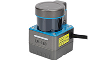
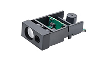
The MVR series laser ranging sensor is a professional ranging product developed by SenkyLaser for this need, which can achieve accurate height determination of drones. The MVR LiDAR sensor is a low-power, high-precision, small-size ranging module that emits near-infrared light at high frequency. It is installed under the UAV, which can detect the distance information of the ground directly below the radar in real time and feed it back to the UAV, so that the UAV can adjust the descent speed or flight height in time during the descent or hovering process.

First of all, the MVR series of laser ranging sensors use high frequency laser beam scanning technology, which can scan the surrounding objects several times in a short time, so as to ensure high precision. Moreover, the frequency of the sensor can reach up to 200Hz, and the scanning speed is fast, which can adapt to high-speed moving drones.
Secondly, the measurement range of the MVR series laser ranging sensor can reach 14 meters, which is more suitable for the fixed height needs of drones in the air.
Moreover, the measurement error of the sensor is only cm level, which can ensure the safety and accuracy of the UAV in the air.
In addition, the small size, light weight and low price of this sensor is very suitable for application in drones, whether small or large models can be used. In short, the MVR series of laser ranging sensors can achieve accurate and reliable height determination of drones, which will play an important role in the application of drones in the fields of aerial photography, reconnaissance, rescue and so on.
MVR3EB-performance Parameter Table:

PREV:NO
NEXT:NO
13391208082
Telephone:+86-21-60340122
Phone number:17317261651
Postal Code:200434